
My name is Rephrain Archaimeric, you can call me Rephrain. Right now I'm still in college taking the Data Science major for Bachelor at University of Parahyangan, Bandung, West Java, Indonesia. Approximately I will graduate in 2024. For now, beside doing my responsibility as a student, I have done some project from Kaggle. One of my strengths on java, python, and html programming. I'm pretty sure that I could accomplish many problem using java, python, and html. I most often use python for data analysis and exploration using machine learning.
rephrain (rephrain)
MySQL Java HTML Geospatial Data Analysis Data Mining Visual Studio Code Phyton Machine Learning Data Science
Hire Me
Make a Private Project
Invite to Bid
Existing Projects
Make a Private Project
Invite to Bid
Existing Projects
| User Name: | rephrain |
| Account Type: | Personal Account |
| Date Registered: | 02/09/2022 21:42:56 WIB |
| Last Seen: | 16/08/2024 09:12:43 WIB |
| Provinsi: | Jawa Barat |
| Kabupaten: | Kota Bandung |
| Website: | https://github.com/rephrain |
| Online Hours: | 288.01 |
| Projects Won: | 0 |
| Projects Completed: | 0 |
| Completion Rate | - |
| Projects Arbitrated: | 0 |
| Arbitration Rate | - |
| Current Projects: | 0 |
Ratings & Rankings
As Worker

0.00/10.00
0 Point
No Ranking
0 Projects
0.00/10.00
0 Point
No Ranking
0 Projects
As Owner
0.00/10.00
0 Point
No Ranking
0 Projects
0.00/10.00
0 Point
No Ranking
0 Projects
As Seller
0.00/10.00
0 Point
No Ranking
0 Sales
0.00/10.00
0 Point
No Ranking
0 Sales
As Affiliate
0.00/10.00
0 Point
No Ranking
0 Users
0.00/10.00
0 Point
No Ranking
0 Users
Services
No record found.
Products
No record found.
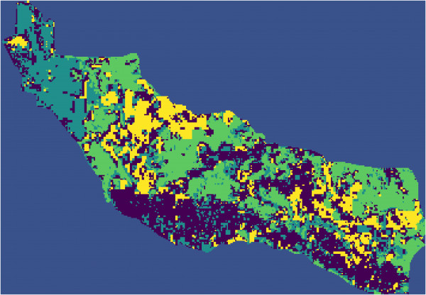
2023: - Analysis using sentinel 2 satellite data from website https://scihub.copernicus.eu/dhus/#/home.
- Light = electromagnetic waves "color" is determined by its wavelength/frequency.
- The human eye can only detect waves with certain frequencies (R,G,B).
- Satellites use sensors with a wider range of frequencies.
- Satellite data is converted into wavelength regions that can be detected (bands).
- Labeling for RGB satellite images (example: labeling pixels for buildings, plants, soil, asphalt, etc) to be used as data train.
- Analysis objective to detect vegetation land cover with classification machine learning.
- General idea: feature transformation based on the idea that there are bands with very different properties
that are very different for plants.
- The classification result is compared with the vegetation index result to find the best result.
- The results are displayed on the software to detect year-to-year changes in vegetation land cover for each region.
No record found.
No record found.
Anda harus login terlebih dahulu untuk melihat data ini.
You must login first to see this data.
 Loading ...